This post is older than 2 years and might not be relevant anymore
More Info: Consider searching for newer posts

GPS field test

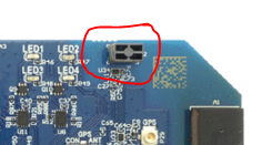
Recently I've been doing GPS field test using DK v0.9.0. I'm using chip antenna on the board and SUPL data.

modem fw v1.2.0
ncs v1.3.0

The result is

- Quickly fix a position at a park in the open sky
- Can't fix a position on a bus. I put the DK near a window
- Can't fix a position on a car. I put the DK on a back sheet
- Can't fix even in traffic circle at station square. It's surrounded by two or three-story buildings and they aren't so high.

Is this common result? I expected smartphone-level GPS fixing ability. I know nRF9160 supports only GPS, while smartphone has more. I guess this makes the difference, but want to know Nordic engineer's field test experience. I'm also wondering if there are some bugs in code. Thank you. 

Parents
  • Hi Yusuke,

    Unfortunately, the performance of the GPS chip antenna on the nrf9160DK v0.9.0 is quite limited which would explain the struggle with getting a fix.

    That is why the latest DKs are shipped with an external MOLEX 206640 GPS antenna. By using the external GPS antenna you should see great improvements. 

    Note that some windows quite efficiently block GPS signals because they have some sort of metallic film. 

    (so inside a BUS can actually be a struggle).


    Generally, 4 satellites are required to get a fix.
    It also depends on how the minimal 4 satellites are positioned in the sky. If they are close to each other, near the horizon, have weak, lossy signal, more satellites may be required.

    There could be some special cases where 3 satellites could be sufficient, but that's not typical use.

    There are 4 unknowns in the equation system that needs to be solved (x, y, z position and receiver clock bias), so 4 satellites are generally required.
    With the increasing number of satellites, the accuracy usually also increases.
    In addition to having strong enough signals from at least 4 satellites, the receiver needs to know the ephemeris data and accurate timing information for each satellite.

    Ephemeris can be received using A-GPS or downloaded from the satellites (which may take a while).

    Timing information is sent from satellites every 6 seconds if I recall correctly, so with A-GPS and fairly clear sky view the expected TTFF is typically RRC inactivity time + 5 seconds or so.

    Note that A-GPS doesn't affect the number of satellites required, as it only provides a faster way to acquire ephemeris/other assistance data and not accurate enough timing information to correct the receiver's clock bias.


    As mentioned earlier the satellites' position also plays a part here and affects accuracy.

    The receiver requires a certain estimated accuracy before calling it a fix.
    There's a new option in the GPS sample that can be used to output NMEA strings: 
    Using the NMEA strings, it's possible to read out for example signal strength, satellite position, and lots of other information that can help debug potential issues.

    There are tools available to assist with this, like VisualGPS and others.

    Best regards,
    Martin L.

  • Thank you for reply.

    Is the poor gps fixing ability caused by nRF9160 chip itself or just the DK board?

    I also testing a custom board. I did impedance matching properly. It also has poor gps fixing

  • Just the GPS antenna on the DK board.
    Please try to test with an external antenna to compare.

  • You mean only the antenna has issue?

    Shouldnt you use chip antennna?

  • Correct, the chip antenna that is on the Development Kit is unfortunately not good, so it is highly recommended to use an external GPS antenna to get the expected performance.

Reply Children
No Data
Related